
Kelvin–Helmholtz Clouds: Ocean-Like Waves Forming in the Sky
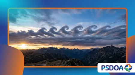
Kelvin–Helmholtz Clouds appear as a series of breaking ocean waves rolling across the horizon, leaving observers in 2026 breathless with their perfect, fleeting symmetry.
Anúncios
These structures emerge from a delicate atmospheric battle where two layers of air move at drastically different speeds, creating a visual masterpiece of fluid dynamics.
While many skygazers mistake these curls for digital glitches or artistic paintings, they represent a rare physical phenomenon that reveals the invisible currents of our atmosphere.
Witnessing these ephemeral waves is like catching a glimpse of the wind’s secret heartbeat, a moment where nature’s raw physics meets pure aesthetic wonder.
Atmospheric Wave Mechanics
- Velocity Shear: Understanding how wind speed differences trigger the curling motion in the clouds.
- Visibility Factors: Why these clouds are so difficult to spot and why they disappear within minutes.
- Geographical Hotspots: Identifying regions where mountainous terrain facilitates the formation of these rolling waves.
- Scientific Significance: How meteorologists use these formations to predict severe turbulence and changing weather patterns.
What creates the ocean-like appearance of these clouds?
The formation of Kelvin–Helmholtz Clouds relies on a process called velocity shear, occurring when a fast-moving upper layer of air glides over a slower, denser bottom layer.
Anúncios
This friction causes the boundary between the two to buckle and roll, mimicking the cresting of waves hitting a shoreline.
Physics dictates that the top layer must move significantly faster than the lower one for the “wave” to successfully curl over into its iconic shape.
This delicate balance of temperature and speed is rarely maintained for long, which explains why these formations often dissipate before a camera can even focus.
How does wind shear work?
Wind shear acts like a cosmic baker rolling out dough, where the pressure and speed of the hands determine the final shape and texture.
In our sky, the invisible hands are high-altitude winds that stretch the cloud top until it can no longer hold its original form.
Meteorologists often find these patterns near mountain ranges where air is forced upward and then accelerated by higher atmospheric currents.
This mechanical forcing provides the necessary energy to transform a flat, boring cloud layer into a rolling sea of white curls and deep shadows.
++ Heiligenschein Halo: The Glowing Ring Around Your Shadow
Why do the waves break?
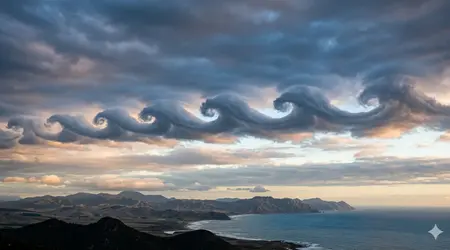
Instability at the interface causes the peaks of the waves to move faster than their bases, eventually toppling over in a surge of motion.
This “breaking” is the exact same fluid dynamic observed in the surf at Malibu, just executed on a massive scale thousands of feet high.
Such movements are a direct visualization of the energy being transferred between different layers of our atmosphere.
They remind us that the sky is not a static void but a churning, liquid-like ocean of gases that responds to the same laws as water.
Why are these formations so rare and difficult to document?
Spotting Kelvin–Helmholtz Clouds requires perfect timing and a keen eye, as the atmospheric conditions needed to sustain them are incredibly volatile.
Most sightings last only two to five minutes before the turbulence becomes too great and the organized waves break into chaotic, messy wisps.
Furthermore, the clouds require a specific amount of moisture enough to make the wind patterns visible, but not so much that the curls are obscured.
This narrow window of opportunity makes them one of the most sought-after prizes for professional weather photographers and climate scientists in 2026.
Also read: Frost Quakes (Cryoseisms): When Frozen Ground Explodes Without Warning
Does location affect sightings?
Specific terrains, such as the Rocky Mountains or the Alps, are known as “factories” for these clouds because they reliably generate the required air disturbances.
Coastal areas also provide the necessary temperature inversions, where cold sea air sits beneath warmer, faster-moving inland currents, creating the perfect stage.
Even in these hotspots, the phenomenon remains elusive, appearing only a handful of times each year under specific meteorological alignments.
Success in documenting them often involves sophisticated satellite tracking and real-time alerts from local weather stations that monitor high-altitude wind gradients.
Read more: The Sinking Forest of Lake Kaindy: Trees Growing Underwater
How does humidity play a role?
Humidity acts as the “ink” that allows us to see the invisible handwriting of the wind across the blue canvas of the sky.
If the air is too dry, the Kelvin–Helmholtz Clouds might still be forming, but there is no vapor to reveal their presence to us.
When the dew point and temperature converge at the exact height of the wind shear, the clouds materialize as if by magic.
This intersection of moisture and movement is what makes the phenomenon a true marvel of the natural world, occurring only when the elements align.
What do these clouds tell us about atmospheric safety?
Analyzing Kelvin–Helmholtz Clouds provides pilots and meteorologists with critical warnings regarding “Clear Air Turbulence,” which is often invisible to traditional radar systems.
These wave patterns are a visual alarm bell, indicating that the sky is experiencing high-energy friction that could pose risks to aircraft.
Data from the World Meteorological Organization (WMO) 2026 Update indicates that regions with frequent wave formations also experience higher incidents of abrupt flight level changes.
Understanding these visual cues allows for better flight planning and increased safety for passengers traveling through turbulent corridors across the globe.
Can they predict local storms?
While the clouds themselves do not always bring rain, they often signal a change in the air mass that precedes cold fronts or storms.
The presence of such high wind shear suggests that the atmosphere is becoming unstable, potentially leading to more aggressive weather developments within the next few hours.
Observers who see these waves should keep a close eye on the barometer, as the shifting currents often herald a drop in pressure.
This makes the phenomenon a functional tool for rural communities and sailors who rely on visual signs to interpret the coming weather.
Why are they named after scientists?
Lord Kelvin and Hermann von Helmholtz were the pioneers who mathematically described the instability of fluids moving at different speeds in the late 19th century.
Their work remains the foundation of how we understand everything from ocean waves to the surface of the sun and our own atmosphere.
Naming the clouds after these titans of physics honors the long history of human curiosity regarding the mechanics of the natural world.
It connects the silent, beautiful curls in the sky to a legacy of rigorous scientific inquiry that continues to evolve in 2026.
2026 Rare Cloud Observation Guide
| Formation Name | Main Visual Feature | Altitude Range | Formation Rarity | Aviation Risk |
| Kelvin–Helmholtz | Breaking Ocean Waves | 16,000 – 30,000 ft | Extremely Rare | High (Turbulence) |
| Asperitas | Stormy Sea Undulations | 6,000 – 13,000 ft | Rare | Medium |
| Nacreous | Iridescent Mother-of-Pearl | 60,000 – 80,000 ft | Very Rare | Low |
| Noctilucent | Electric Blue Night Glow | 250,000 – 280,000 ft | Seasonal | Very Low |
| Mammatus | Pouch-like Bulges | 10,000 – 25,000 ft | Common | High (Storms) |
| Lenticular | Stationary UFO Saucers | 6,500 – 16,500 ft | Uncommon | Medium |
| Undulatus | Parallel Ripples | 6,000 – 10,000 ft | Frequent | Low |
| Fallstreak Hole | Circular Punch-out | 20,000 – 25,000 ft | Rare | Low |
The documented frequency of Kelvin–Helmholtz Clouds has increased recently due to the proliferation of high-resolution smartphone cameras and real-time social reporting.
According to the Cloud Appreciation Society’s 2025 Annual Review, verified sightings have jumped by 15% as more citizens engage in “sky-watching” as a meditative hobby.
Witnessing these clouds is like seeing the wind finally lose its invisibility cloak for a few brief, glorious minutes.
It reminds us that we live at the bottom of a vast, complex fluid ocean that is constantly in motion, even when it appears still.
By understanding the science behind the beauty, we deepen our connection to the planet and the invisible forces that govern our daily lives.
These waves are a reminder that nature does not need a museum to display its most impressive and intricate works of art.
The next time you look up, keep an eye out for the tell-tale curls of a Kelvin–Helmholtz Clouds formation dancing across the blue.
You might just catch a glimpse of the atmosphere’s most elusive and breathtaking performance before it vanishes back into the wind.
Have you ever spotted a wave in the sky that looked too perfect to be real? Share your experience in the comments below!
Kelvin–Helmholtz Clouds represent the perfect intersection of high-level physics and natural art, proving that the sky is a masterpiece in constant, fluid motion.
Frequently Asked Questions
Are Kelvin–Helmholtz Clouds dangerous to watch from the ground?
No, they are perfectly safe to observe from the ground; they only signal turbulence for aircraft flying directly through those specific atmospheric layers.
Can I see these clouds in any part of the world?
While they can occur anywhere, you are most likely to see them in mountainous regions or near coastlines where air layers often have different speeds.
Why do they disappear so quickly?
The turbulence that creates the waves eventually destroys the organized structure, causing the clouds to mix and lose their distinct “ocean wave” shape within minutes.
How do I take a good photo of them?
Use a fast shutter speed to capture the sharp edges of the curls and look for high-contrast lighting, such as during sunrise or sunset, to define the shadows.