
Mammatus Clouds: The Bubble-Shaped Storm Clouds Explained
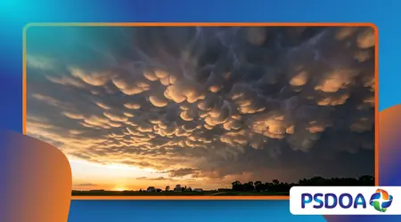
Mammatus Clouds present one of the most stunning, dramatic, and intensely captured visual spectacles in the entire field of modern meteorology.
Anúncios
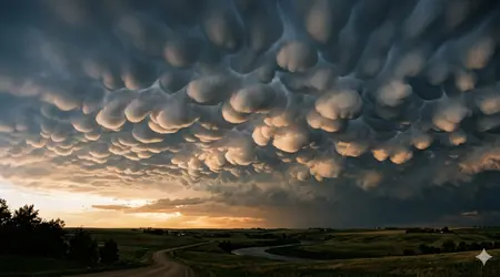
These unique, pocket-like pouches hang conspicuously from the underside of a cloud base, astonishing onlookers who expect typical flat cloud formations.
Their striking resemblance to smooth, rolling bubbles frequently triggers intense public curiosity and widespread viral social media trends during severe storm seasons.
Understanding the atmospheric physics behind these dramatic formations helps observers accurately read incoming severe weather patterns.
Experienced storm chasers rely heavily on these pouches to locate the most intense regions of a collapsing convective cell. The appearance of these bulbous structures marks a fascinating intersection of intense fluid dynamics and visual beauty in our skies.
Key Meteorological Highlights
- Severe Weather Indicators: Frequently associated with intense, mature cumulonimbus storm systems and passing tornadoes.
- Unique Physics: Formed by sinking pockets of cold, moist air rather than the typical rising currents.
- Aviation Hazards: Indicate severe localized turbulence, strong wind shear, and dangerous microburst potential for nearby aircraft.
What are Mammatus Clouds and How Do They Form?
The international meteorological community classifies these pouch-like structures as a distinct cloud supplement rather than an independent, isolated cloud type.
They develop primarily on the underside of massive cumulonimbus anvils, extending outward over hundreds of square kilometers of sky.
Have you ever wondered why the atmosphere suddenly shifts from flat layers to these hyper-defined, hanging celestial bubbles?
While most cloud formations grow through rising air currents, mammatus clouds require powerful, moisture-heavy sinking air to carve out their shapes.
This reversal of typical cloud dynamics creates a dramatic visual display that feels almost alien to ground-based observers. The resulting pouches can extend downward for several hundred meters, creating a heavily textured ceiling across the horizon.
Consider a simple oil-and-water mixture inside a glass container to visualize this complex fluid interaction easily. When you introduce a heavier, denser fluid on top, gravity naturally pulls it downward into smooth, rounded pockets.
The atmosphere replicates this exact process when cold, ice-heavy air sinks into a warmer, drier layer underneath the storm anvil.
Meteorological studies from the National Oceanic and Atmospheric Administration (NOAA) confirm that individual pouches survive for merely fifteen to thirty minutes.
This short lifespan makes capturing a fully developed field of these clouds an incredibly rare, highly prized achievement for photographers.
Their rapid evolution proves how volatile and fast-changing our upper atmosphere remains during major convective events.
How Does Subsidising Air Shape the Pockets?
As heavy ice crystals evaporate inside the sinking air current, they cool the surrounding atmosphere at an accelerated rate. This intense cooling process increases the density of the air pocket, forcing it to plummet faster through the cloud base.
The surrounding upward thermal currents compress these sinking columns, sculpting the distinct, uniform bubble shapes we see.
++ Steam Devils: Rare Tornado-Like Vortices
What Atmospheric Conditions are Required?
A stark contrast in temperature and moisture levels between the cloud anvil and the underlying air mass must exist simultaneously.
High convective instability in the lower troposphere pushes moisture upward, while dry air below forces rapid evaporation and downward sinking.
Without this exact thermodynamic battle, the smooth, rounded pouch structures cannot stabilize.
Also read: Frost Quakes (Cryoseisms): When Frozen Ground Explodes Without Warning
Where Do They Most Frequently Appear?
The Great Plains of the United States, known widely as Tornado Alley, experience these formations regularly during peak spring months.
However, intense tropical systems in northern Australia and heavy summer convective storms across central Europe also generate magnificent, documented examples.
Any geographic region capable of producing massive supercell thunderstorms can host these remarkable formations.
Why Do These Formations Signal Severe Weather?
The presence of mammatus clouds serves as a loud, visual warning system from nature regarding the immense energy moving through the atmosphere.
They consistently manifest after the main thermodynamic storm front passes, revealing the incredible volume of moisture trapped in the upper troposphere. Their presence confirms that the parent storm possesses immense updrafts capable of lifting tons of water.
A common misconception among casual observers is that these specific bulbous shapes directly generate tornadoes or destructive hail onto the ground.
In reality, they represent the architectural leftovers of a highly organized, mature supercell that is already discharging its energy nearby. They show us the sheer scale of the storm’s exhaust system high above our heads.
For example, a severe thunderstorm over Kansas might display breathtaking, golden-hued pouches across its eastern flank while the western core drops heavy rain.
This physical separation allows ground observers to view the beautiful structures safely without experiencing immediate, life-threatening weather conditions. The visual contrast between the dark storm core and glowing pouches remains unparalleled.
Safety professionals emphasize that while the pouches themselves do not drop lightning, the surrounding environment remains highly volatile and dangerous.
Wind shear around these formations can fluctuate wildly within seconds, presenting significant challenges for local weather forecasting teams. Appreciating their beauty requires a respectful understanding of the dangerous forces creating them.
Read more: The Sinking Forest of Lake Kaindy: Trees Growing Underwater
What Risks Do They Present to Aviation?
Commercial pilots actively avoid flying directly underneath these bumpy cloud bases due to extreme, unpredictable vertical wind currents.
The intense downdrafts that create the pouches can cause severe structural stress to aircraft and induce sudden, terrifying altitude drops. Flight paths routinely redirect around these zones to ensure passenger safety.
How Do Scientists Predict Their Appearance?
Meteorologists utilize advanced Doppler radar networks to track the rapidly expanding anvil zones of severe, rotating supercell systems.
By measuring the velocity of upper-level winds and tracking moisture density, software can pinpoint where these structural collapses will occur. This real-time data helps photographers position themselves perfectly before the sun sets.
Why Do They Produce Such Intense Colors?
The unique, low angle of a setting sun forces light rays through an incredibly thick layer of the Earth’s atmosphere.
This filtering process scatters blue wavelengths, leaving vibrant oranges, deep reds, and rich gold tones to illuminate the hanging cloud pockets. The resulting high-contrast shadows maximize the three-dimensional appearance of the sky.
How Do Researchers Study These Transitory Phenomena?
Capturing accurate, real-time data inside a volatile storm anvil requires a sophisticated mix of remote sensing tools and physical probes.
Weather research centers deploy specialized radar systems that can pierce through dense precipitation layers to measure internal cloud velocities. These tools allow scientists to map the precise boundary lines where cold and warm air collide.
Deploying automated weather balloons directly into the path of an advancing supercell provides crucial thermodynamic readings from inside the cloud structure.
These instruments transmit pressure, humidity, and temperature data every second as they ascend through the turbulent convective layers. This information helps validate the theoretical computer models used to predict global weather changes.
Using another practical example, research aircraft equipped with laser-based LiDAR systems occasionally fly along the margins of these active storm anvils.
The collected data creates highly detailed, three-dimensional models of individual cloud pouches, revealing internal circulation patterns never seen before. These engineering achievements transform our understanding of atmospheric boundaries.
Furthermore, the explosion of high-resolution smartphone cameras and crowdsourced weather apps provides scientists with thousands of concurrent visual data points.
Combining citizen science photographs with orbital satellite imagery allows research teams to track the exact lifecycle of these phenomena across entire continents. This collaborative approach accelerates modern meteorological discoveries.
What Do Satellite Sensors Reveal?
Modern geostationary satellites monitor the top of storm anvils using infrared sensors to detect the intense cooling trends associated with cloud expansion.
When the top of an anvil flattens out completely, it indicates that the underlying base is ready to produce severe downward pocketing. These space-based observations provide crucial early warnings for ground teams.
How Do Microphysical Processes Affect Lifespan?
The precise ratio of liquid water droplets to solid ice crystals inside the anvil determines how long the pouches retain their shape.
If the air below is excessively dry, the ice sublimates too quickly, causing the structures to dissolve into generic gray haze. A delicate, temporary balance must exist to sustain the smooth contours.
What Can We Learn From Historical Records?
Early maritime logs and historical weather diaries from the nineteenth century contain vivid descriptions of these breast-like cloud formations before modern photography existed.
Comparing these historical descriptions with modern digital archives helps climatologists determine if changing global temperatures alter the frequency of severe convective storms. This historical context grounds our current research.
Meteorological Characteristics of Hanging Cloud Structures
The structural variation of these atmospheric formations depends heavily on upper-level wind speeds and the total moisture volume within the convective cell. The following table details the physical properties observed during peak development stages.
Atmospheric Profiles of Cumulonimbus Pouches
| Structural Variant | Average Pocket Diameter | Primary Composition | Associated Weather Severity | Typcial Visibility Window |
| Classic Bulbous | 1.5 – 3.0 Kilometers | Heavy Ice Crystals & Liquid Water | Severe Supercells & Tornadoes | 15 – 20 Minutes |
| Elongated Ridges | 0.5 – 1.5 Kilometers | Mostly Evaporating Liquid Water | Standard Squall Lines | 10 – 15 Minutes |
| Diffuse Waves | 2.0 – 5.0 Kilometers | Thin Ice Needles & Vapor | Weakening Convective Storms | 20 – 30 Minutes |
Final Reflections on Atmospheric Wonders
The mesmerizing presence of mammatus clouds reminds us of the incredible, dynamic forces that constantly shape our planet’s atmosphere.
These bubble-shaped wonders convert a terrifying storm system into an unforgettable canvas of light, shadow, and immaculate fluid geometry.
By studying these short-lived structures, meteorologists unlock deeper insights into storm intensity, helping protect communities through improved severe weather forecasting.
Have you ever witnessed these incredible cosmic bubbles filling the horizon during a local summer storm? Share your personal experiences and location details in the comments section below to help us map these global phenomena!
Frequently Asked Questions
Can mammatus clouds form in the absence of a thunderstorm?
While they occasionally develop beneath altocumulus or stratocumulus layers, the most dramatic and fully formed pouches require the immense energy and moisture of a mature cumulonimbus storm anvil.
Are these unique cloud pouches dangerous to people on the ground?
The cloud pockets themselves do not pose a direct physical danger, but they signal that a highly volatile, potentially hazardous thunderstorm system is active in the immediate geographic area.
How long does a typical field of these bubbles remain visible?
An individual pocket usually retains its distinct, smooth shape for fifteen to thirty minutes before changing wind patterns and evaporation dissolve the structure into surrounding clouds.
