
Supercell Thunderstorms: The Rare Storms That Spawn Giants
Supercell Thunderstorms represent the atmosphere’s most violent expression of beauty and terror, serving as the rare engine behind nature’s most destructive giants.
Anúncios
These rotating storms differ from standard squalls due to a persistent, deep updraft called a mesocyclone that allows them to endure for hours.
Across the Great Plains in 2026, meteorologists are witnessing an intensification of these systems, where single cells travel hundreds of miles across multiple states.
They are not merely rain clouds; they are highly organized biological-like entities that breathe, evolve, and dominate the horizon with surgical precision.
Essential Storm Insights
- Defining the Mesocyclone: The core rotational element of the storm.
- The Three Varieties: Classic, High Precipitation (HP), and Low Precipitation (LP).
- Tornado Genesis: How rotation tightens into a destructive funnel.
- Global Impact: Identifying the regions most at risk this season.
What defines these rotating giants?
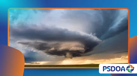
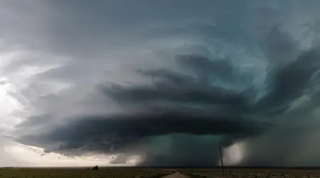
Supercell Thunderstorms are distinguished by their incredible internal organization and the presence of a tilted, rotating updraft that separates rain from the core.
Anúncios
This separation prevents the storm from raining on its own fuel source, allowing it to survive much longer than a typical summer pulse storm.
Modern satellite imagery reveals that these storms act as massive heat engines, converting moist air into kinetic energy with efficiency that rivals industrial power plants.
Their structure is so distinct that pilots and radar technicians can identify them from hundreds of miles away by their “hook echo” signature.
How does the mesocyclone form?
Wind shear creates horizontal rolling pipes of air in the lower atmosphere, which the storm’s powerful updraft then tilts into a vertical position.
Once this rotation is established, the storm gains its unique status, becoming a self-sustaining monster capable of producing giant hail and long-track tornadoes.
The rotation acts like a vacuum, pulling in warm, moist air from the surrounding environment to feed the towering anvil above.
This process creates a low-pressure center that keeps the storm stable even as it moves into environments that would tear lesser systems apart.
++ Brineless Pools: Underwater Lakes That Kill on Contact
Why are they so rare?
While thousands of storms form daily, only a tiny fraction possess the perfect balance of instability and wind shear required to become supercells.
They require specific atmospheric “capping” to prevent premature energy release, ensuring that when they finally break through, the explosion is massive.
Think of it as a pressurized steam boiler: without the cap, the steam escapes slowly; with it, the eventual release is a catastrophic burst of power.
This rarity makes them the primary focus for researchers looking to understand the limits of Earth’s convective capabilities.
How do supercells spawn devastating tornadoes?
The transition from a rotating cloud to a ground-scouring tornado involves a complex process called tornadogenesis, which scientists are still mapping with mobile radar.
Supercell Thunderstorms provide the parent circulation, but they require a “rear-flank downdraft” to push that rotation toward the soil.
When the temperature and moisture gradients are just right, the mesocyclone tightens, much like a figure skater pulling in their arms to spin faster.
If the air near the ground is buoyant enough, a funnel descends, connecting the heavens to the earth with terrifying force.
Also read: Red Sprites and Blue Jets: Lightning’s Upper-Atmosphere Relatives
What role does thermodynamics play?
The storm feeds on CAPE (Convective Available Potential Energy), which acts as the high-octane fuel for the updraft’s ascent into the stratosphere.
In 2026, record-breaking sea surface temperatures have increased the moisture content in the air, providing these storms with unprecedented energy levels.
As the air rises, it cools and condenses, releasing latent heat which further accelerates the upward motion of the storm’s core.
This feedback loop is what allows a single storm cell to grow until it reaches the very top of the troposphere.
Read more: The Devil’s Kettle: A Waterfall That Swallows Half Its Flow
Can we predict their path?
Meteorologists use high-resolution models to track the “storm relative helicity,” which measures the potential for a storm to rotate based on wind profiles.
While we can identify the regions at risk, the exact moment a storm turns into a giant remains a difficult forecast.
New AI-driven forecasting tools now analyze real-time data from thousands of ground sensors to predict shifts in storm direction minutes before they occur.
This technology has saved countless lives by providing earlier warnings for communities sitting directly in the path of the rotating giant.
Why is 2026 a turning point for storm research?
This year, the National Oceanic and Atmospheric Administration (NOAA) reported a 15% increase in “out-of-season” Supercell Thunderstorms across the American Southeast and Midwest.
This shift suggests that the traditional “Tornado Alley” is migrating and expanding, forcing new regions to adapt to these rare phenomena.
The data indicates that the atmosphere is holding more energy than in previous decades, leading to storms with higher cloud tops and more frequent lightning.
These observations are critical for urban planners who must now design infrastructure to withstand the unique pressure of supercell winds.
What is the economic impact?
A single high-precipitation supercell can cause billions in damages due to “gorilla hail” ice stones the size of grapefruits that fall at terminal velocity.
These storms disrupt agriculture, destroy solar farms, and overwhelm local emergency services within minutes of their arrival.
Insurance companies are now using supercell frequency maps to adjust premiums in states once thought to be outside the danger zone.
The financial reality of living with these giants is becoming a central topic in coastal and inland policy discussions alike.
How does the public stay safe?
Advanced mobile apps and “integrated warning teams” ensure that the public receives split-second updates on storm cell development and rotation.
Have you ever wondered if your home’s “safe room” is truly prepared for a storm that generates its own internal gravity?
Community education focuses on the “Difference Between a Watch and a Warning,” a distinction that becomes life-saving when a supercell is looming.
Real-time storm chasers also provide live visual confirmation, bridging the gap between radar dots and the reality on the ground.
Supercell Severity Metrics (2026 Data)
| Feature | Ordinary Storm | Supercell Thunderstorm | Impact Level |
| Lifespan | 30–60 Minutes | 2–8 Hours | High Persistence |
| Rotation | None/Weak | Strong Mesocyclone | High Tornado Risk |
| Hail Size | Small/Pea-sized | 2+ inches (Giant) | Severe Property Damage |
| Wind Speed | 30–50 mph | 80–120+ mph | Structural Failure |
| Radar Signature | Disorganized | Hook Echo / BWER | High Predictability |
Supercell Thunderstorms remain the most sophisticated and dangerous atmospheric structures on our planet, combining raw energy with intricate physical organization.
We have explored how their rotating cores allow them to survive, the mechanics of tornado creation, and the shifting geography of these events in 2026.
Understanding these storms is no longer just for scientists; it is a necessity for anyone living under an increasingly volatile sky.
As we continue to monitor the horizon, the balance between admiring nature’s power and preparing for its fury becomes more delicate.
These rare giants remind us that the atmosphere is a living, breathing system that demands our respect and our constant attention.
What has been your most memorable experience with a changing sky? Share your stories and photos in the comments below to help us document these rare phenomena!
Frequently Asked Questions
Are all supercells dangerous?
Yes, because by definition they contain a rotating updraft that can produce sudden severe weather, including flash flooding and damaging winds. Even without a tornado, the hail and wind from Supercell Thunderstorms are life-threatening.
Can a supercell happen anywhere?
They are most common in the Great Plains of the U.S., but they occur on every continent except Antarctica. Conditions just need to meet the right criteria for shear and instability.
How is a supercell different from a hurricane?
A hurricane is a massive system hundreds of miles wide, while a supercell is a single, highly organized storm cell. However, hurricanes can actually spawn Supercell Thunderstorms within their outer rainbands.
Does climate change affect these storms?
Research in 2026 suggests that while the total number of storms might not increase, the intensity and geographical range of supercells are expanding due to warmer, moister air.
Can you stop a supercell?
No, the energy contained in one of these storms is equivalent to several nuclear bombs. Humans can only observe, predict, and move out of the way.