
Pyrocumulus Clouds: Thunderstorms Created by Extreme Wildfires
Pyrocumulus Clouds: Thunderstorms created by extreme wildfires represent one of the most violent and awe-inspiring spectacles of modern atmospheric science, bridging the gap between severe meteorological disruption and catastrophic ecological collapse.
Anúncios
When roaring infernos release colossal thermal updrafts into the troposphere, they forge towering pyrocumulus formations often evolving into pyrocumulonimbus clouds that dictate their own weather patterns, generate localized lightning, and further exacerbate spreading flames.
As global temperatures rise and wildfire seasons intensify across diverse continents, understanding these pyro-convective anomalies has become essential for meteorologists, firefighters, and affected communities alike.
Quick Navigation
- What is the genesis of these fire-induced storms?
- How do extreme thermal updrafts alter local weather?
- Why do these formations pose unprecedented tactical firefighting challenges?
- What structural differences separate standard clouds from pyro-convection?
- How does atmospheric instability fuel rapid vertical cloud growth?
- What role do moisture and particulate matter play in condensation?
- Which historical wildfire events recorded the most massive pyrocumulus plumes?
- How do climatologists monitor these dangerous atmospheric phenomena today?
- What future outlook exists for predicting extreme fire-weather interactions?
What is the genesis of these fire-induced storms?
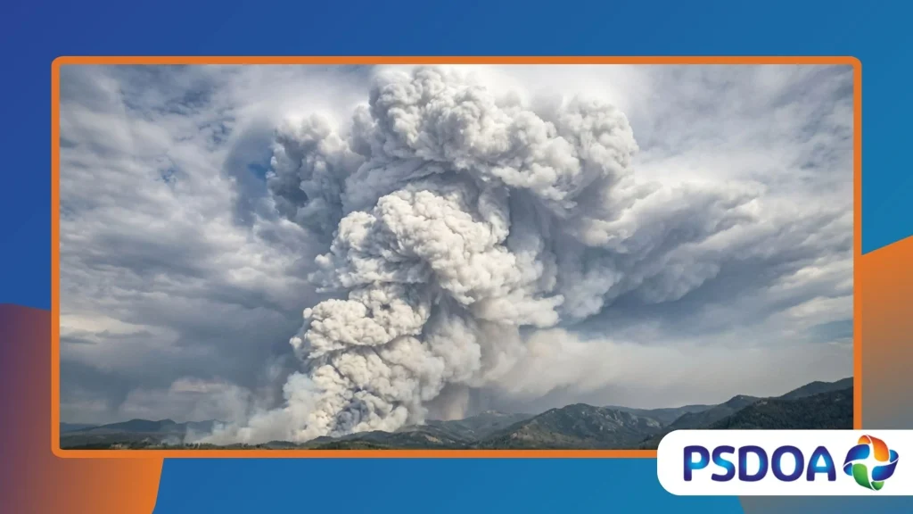
Pyrocumulus clouds emerge when intense surface heat from massive wildfires or volcanic eruptions forces a rapid, aggressive vertical ascent of warm air.
This thermal buoyancy pushes massive volumes of heated air, water vapor, and particulate ash high into the atmosphere, where cooler ambient temperatures trigger immediate condensation around airborne soot particles.
The resulting billowing cloud resembles a traditional cumulus formation but carries the dark, menacing signature of ash, smoke, and destruction directly from the forest floor into the upper boundary layer.
Inside this churning cauldron of smoke and moisture, intense thermal energy continues to drive the column upward with astonishing velocity.
As the parcel of air ascends, adiabatic cooling causes moisture released by burning vegetation and ambient humidity to condense rapidly, forming dense white and gray cumulus domes atop the dark smoke plume.
This initial stage marks the dangerous transition from a standard wildfire smoke column to a dynamic, self-sustaining atmospheric engine driven entirely by the fury of the blaze below.
How do extreme thermal updrafts alter local weather?
Fierce thermal updrafts within these towering cloud structures fundamentally disrupt local atmospheric pressure gradients, creating sudden, erratic wind storms that confound ground crews.
As superheated air rushes upward, cooler surrounding air is violently sucked into the base of the fire, generating ferocious horizontal surface winds that fan the flames into unpredictable new directions.
This atmospheric feedback loop turns a steady-burning wildfire into an explosive, fast-moving conflagration capable of jumping natural firebreaks and wide rivers with ease.
Beyond surface wind acceleration, the towering vertical columns alter humidity and temperature profiles across several thousand square meters of the lower troposphere.
The localized low-pressure zones created by rising heat draw in moisture from adjacent unburned regions, occasionally producing localized downpours that fail to reach the ground because they evaporate in the scorching ambient heat.
Instead of extinguishing the fire, these evaporated downdrafts hit the ground as erratic, dry microbursts that spread embers in a terrifying 360-degree radius.
++ Marine Snow: The Strange Underwater Blizzard in Deep Oceans
Why do these formations pose unprecedented tactical firefighting challenges?
Tactical firefighting operations face near-impossible hurdles when an intense blaze triggers large-scale pyro-convective activity overhead.
The sudden generation of severe turbulence, unpredictable wind shears, and lightning strikes makes aerial firefighting via helicopters and air tankers exceptionally hazardous, forcing ground commanders to ground crucial air support precisely when it is most urgently needed.
Furthermore, the blinding darkness caused by thick ash plumes combined with choking smoke severely limits visibility for evacuation and containment strategies.
Safety margins for frontline firefighters evaporate instantly when these towering cloud structures undergo sudden collapse or transition into electrified storms.
When the upward thermal momentum weakens or becomes saturated with heavy precipitation, the entire plume can collapse downward, unleashing violent, superheated winds known as firestorms across containment lines.
This extreme operational hazard requires specialized meteorological forecasting and immediate retreat protocols to prevent catastrophic loss of life among emergency responders.
What structural differences separate standard clouds from pyro-convection?
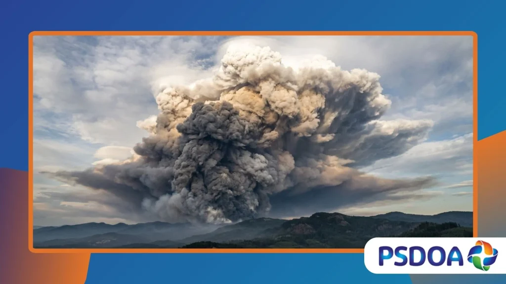
Standard cumulus clouds form through gentle solar heating of the Earth’s surface, resulting in slow, uniform parcel buoyancy and predictable atmospheric cumulus development.
In stark contrast, pyrocumulus structures are driven by the explosive, concentrated thermal output of a massive combustion event, injecting millions of tons of black carbon, ash, and chemical pollutants directly into the mid-troposphere.
This high concentration of condensation nuclei ensures that water droplets form rapidly around solid soot particles rather than microscopic salt crystals or dust.
The physical appearance of these fire-born clouds is equally distinctive, characterized by a dirty-brown or charcoal-gray core beneath brilliant white, cauliflower-like domes that tower into the stratosphere.
While ordinary cumulus clouds dissipate peacefully as evening cooling sets in, pyrocumulus formations often persist long after sunset, fueled by the relentless residual heat of burning timber, peat, and organic soil layers.
This structural resilience allows them to evolve deep into the night, occasionally transforming into fully electrified thunderstorms.
Also read: Dust Veils: Atmospheric Layers That Turn Sunsets Purple
How does atmospheric instability fuel rapid vertical cloud growth?
Atmospheric instability acts as the primary atmospheric accelerator for explosive vertical cloud development during severe wildfire outbreaks.
When environmental lapse rates the rate at which atmospheric temperature decreases with altitude are exceptionally steep, a rising thermal parcel encounters progressively warmer conditions relative to its surroundings, encouraging it to shoot upward like a rocket.
This unrestrained vertical acceleration allows fire plumes to punch through the capping inversion layer and reach heights exceeding twelve kilometers into the stratosphere.
Meteorologists utilize stability indices such as the Lifted Index and Convective Available Potential Energy to assess whether a region’s atmosphere can support extreme pyro-convective blowups.
During periods of severe drought and high ambient temperatures, these stability parameters often reach critical thresholds, meaning any major wildfire has the immediate potential to trigger towering atmospheric disturbances.
Consequently, understanding lower-troposphere instability remains a vital component of modern fire-weather prediction models used worldwide.
Read more: Mammatus Clouds: The Bubble-Shaped Storm Clouds Explained
What role do moisture and particulate matter play in condensation?
Water vapor released by burning biomass and transpired by stressed vegetation provides the essential moisture needed to fuel cloud condensation within the rising column.
As organic matter combusts, hydrogen and oxygen compounds break down and vaporize, injecting copious amounts of water vapor directly into the thermal updraft alongside millions of microscopic carbon ash particles.
These soot particles act as highly efficient cloud condensation nuclei, allowing water droplets to form at lower relative humidity levels than would occur in clean air.
The abundance of these particulate condensation nuclei results in a dense concentration of remarkably small cloud droplets within the rising plume.
Because these droplets are numerous and tiny, they inhibit standard collision-coalescence precipitation processes in the early stages, keeping the cloud reflective and bright white at its peak.
However, as the updraft intensifies and ingests surrounding ambient moisture, these tiny droplets rapidly coalesce around larger ash cores, paving the way for heavy droplet growth and eventual electrification.
Which historical wildfire events recorded the most massive pyrocumulus plumes?
Australia’s catastrophic Black Summer bushfires of 2019 and 2020 produced some of the most extensively documented pyro-convective events in modern meteorological history.
During this unprecedented crisis, dozens of independent pyrocumulonimbus clouds erupted simultaneously, injecting an estimated one million metric tons of smoke and aerosol particles directly into the stratosphere, where they circled the globe for months.
These colossal plumes rivaled the atmospheric impact of major volcanic eruptions, altering local radiation budgets and stunning researchers worldwide.
Similarly, the massive Canadian wildfire seasons of recent years have generated record-breaking pyrocumulus activity across remote boreal forests.
In 2023, ferocious fires in Quebec and the Northwest Territories produced towering convective plumes that darkened skies thousands of miles away in New York and Europe, demonstrating the transcontinental reach of these extreme fire-weather events.
Documented satellite observations from these crises confirmed that extreme pyro-convection is an escalating global phenomenon driven by shifting climatic norms.
How do climatologists monitor these dangerous atmospheric phenomena today?
Advanced geostationary and polar-orbiting satellites now provide real-time multispectral imaging that allows climatologists to track pyrocumulus evolution with astonishing precision.
Instruments equipped with infrared sensors can detect intense thermal anomalies on the forest floor while simultaneously measuring cloud-top temperatures, aerosol optical depth, and plume height as they surge into the upper atmosphere.
This high-resolution data streams directly into predictive models, giving researchers invaluable insights into how fires manipulate regional weather.
Ground-based Doppler weather radars complement satellite surveillance by capturing the internal velocity, wind shear, and precipitation patterns within mature pyrocumulonimbus storms.
By analyzing radar reflectivity and lightning detection networks, scientists can identify when a smoke plume has transitioned into an electrified thunderstorm capable of generating dry lightning strikes.
These secondary lightning strikes frequently ignite new spot fires miles ahead of the main front, complicating containment efforts significantly.
What future outlook exists for predicting extreme fire-weather interactions?
The future of wildfire management hinges on integrating sophisticated meteorological forecasting with artificial intelligence to predict pyro-convective blowups before they occur.
Researchers are developing high-resolution numerical weather prediction models that simulate the complex coupling between surface combustion dynamics and upper-air thermodynamics.
By identifying critical thresholds of atmospheric dryness, fuel load, and wind shear, these emerging tools aim to provide early warning alerts to firefighters in high-risk zones.
As global climate change continues to expand the frequency and severity of extreme drought conditions, understanding the mechanics of these towering fire clouds transitions from an academic pursuit to an urgent survival necessity.
Enhanced international collaboration and data sharing among fire agencies, meteorologists, and climate scientists will ultimately dictate how effectively humanity adapts to an era of mega-fires and self-generated firestorms.
| Meteorological Metric | Standard Cumulus Formation | Extreme Pyrocumulus Formation |
| Primary Energy Source | Solar surface heating of land | Combustion heat from massive wildfires |
| Updraft Velocity | Moderate 1 m/s para 5 m/s | Extreme (10 a 50+ m/s) |
| Aerosol Composition | Natural salt, dust, and water vapor | Dense carbon soot, ash, and combustion gases |
| Stratospheric Penetration | Rare, restricted to severe storms | Common during extreme mega-fire events |
Final Reflections
The terrifying majesty of these fire-born storms reminds us of the profound, intricate feedback loops connecting terrestrial ecosystems with atmospheric mechanics.
Mitigating the growing threat of mega-fires requires an unprecedented global commitment to sustainable land management, aggressive emissions reduction, and advanced technological preparedness.
Share your thoughts or local observations on extreme weather events in the comments below.
Frequently Asked Questions
What exact atmospheric conditions trigger pyrocumulus cloud formation above a wildfire?
These towering clouds ignite when intense, concentrated surface thermal energy from massive wildfires creates extreme upward buoyancy, forcing superheated air, smoke, and moisture rapidly into the troposphere where it condenses around dense particulate matter.
How do pyrocumulonimbus storms differ from normal summer thunderstorms?
While both generate heavy precipitation, lightning, and intense updrafts, pyrocumulonimbus storms are artificially fueled by continuous surface combustion energy and contain massive concentrations of toxic smoke, soot, and ash rather than clean water vapor alone.
Can these fire-induced clouds actually help extinguish the wildfires that created them?
Rarely; while these convective plumes frequently produce localized precipitation and downpours, the intense heat of the underlying inferno usually causes rain to evaporate before hitting the ground, often generating dangerous dry microbursts and erratic surface winds instead.
Why do meteorologists and firefighters monitor pyro-convection so closely during fire season?
Firefighters and meteorologists track these violent formations because they signal unpredictable wind shears, explosive fire spread, sudden column collapses, and dangerous lightning strikes that threaten frontline safety and overwhelm traditional containment strategies.
What global impact do massive pyrocumulus plumes have on the Earth’s atmosphere?
When these explosive plumes surge into the stratosphere, they inject millions of tons of black carbon and aerosol particles that linger for months, altering regional radiation balances, impacting global weather patterns, and influencing atmospheric chemistry worldwide.
